
- Видео 589
- Просмотров 4 288 436
Terra Spatial
Индия
Добавлен 6 ноя 2016
This channel provides assistance for education and technology related to GIS and Remote Sensing for daily usage. On average, 15 to 20 videos are published monthly. It is delivered to subscribers on Monday, Tuesday, Wednesday and Thursday.
Introduction to Remote Sensing: How Can Satellite Images be Interpreted and Used | Part 12
We've also learned to correct image errors in brightness and geometry, ensuring we have high-quality data ready for analysis. Now, we explore two main approaches for interpreting images from remote sensing platforms. The first approach, photointerpretation, involves skilled analysts visually examining images to extract meaningful information. This traditional method relies on understanding color, brightness, and object relationships within images. The second approach leverages sophisticated computer algorithms for quantitative analysis, classification, and even machine learning. These methods involve human expertise in optimizing computer-based interpretations rather than direct image ana...
Просмотров: 220
Видео


Branching, Precondition, and Field Calculations Using Model Builder in ArcGIS | Part 2
Просмотров 1754 часа назад
Hello everyone, and welcome back to our in-depth ArcGIS series! In this video, we pick up from where we left off, continuing our journey of building a robust town relocation tool using Model Builder in ArcGIS. Last time, we successfully copied the feature class, added and calculated the IS river field, and set its value for parcels intersecting with the river. In this session, we'll introduce b...

Introduction to Groundwater Flow Modeling Groundwater: Aquifer and their Classification | Part 2
Просмотров 3917 часов назад
Welcome back to the second video (Part 2) of our course on groundwater flow modeling using MODFLOW and GMS. In this video, we delve into one of the most crucial aspects of groundwater hydrology: groundwater aquifers. Understanding aquifers is key to grasping how groundwater is stored, transmitted, and flows through different geological formations. Aquifers are porous media or sediments where gr...

Create Rainfall Map using Kriging Interpolation Method in ArcGIS Pro
Просмотров 1759 часов назад
Unlock the power of geostatistics with our step-by-step guide on creating rainfall maps using the Kriging interpolation method in ArcGIS Pro. In this comprehensive tutorial, we’ll take you through the entire process, from understanding the basics of Kriging to visualizing your rainfall data on an accurate and informative map. Rainfall mapping is essential for various applications such as agricu...
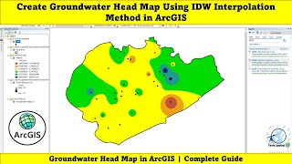
Create Groundwater Head Map Using IDW Interpolation Method in ArcGIS
Просмотров 42012 часов назад
Understanding groundwater dynamics is crucial for water resource management, environmental protection, and engineering applications. In this video, we'll guide you through creating a groundwater head map using the IDW interpolation method in ArcGIS. We’ll cover essential concepts like groundwater head (GWH) and groundwater level and show you how to practically apply these concepts to generate a...

Download Active Fire data From FIRMS & Visualize with ArcGIS Pro and Google Earth Pro
Просмотров 28821 час назад
In this tutorial, you'll learn how to download and visualize active fire data from the Fire Information for Resource Management System (FIRMS) using ArcGIS Pro and Google Earth Pro. We'll start by accessing the FIRMS database, which provides up-to-date global fire data, crucial for resource management, environmental monitoring, and disaster response. You'll learn how to download this data, ensu...

Introduction to Fundamentals of Groundwater Flow Modelling Using MODFLOW & GMS | Beginners Tutorial
Просмотров 609День назад
Welcome to the second video of our course, "Basics of Groundwater Flow Modeling Using MODFLOW". In this video, we delve into the general introduction to groundwater, laying a solid foundation with essential definitions and concepts to ensure we are all on the same page throughout this course and beyond. We start by discussing the three main Earth materials: rocks, sediments, and fluids. Underst...

Create and Export Flood Simulation for Adyar River Basin Using ArcGIS Pro 3.3
Просмотров 630День назад
In this video, we guide you through creating a flood simulation for the Adyar River Basin using ArcGIS Pro 3.3. We demonstrate how to model water movement and accumulation within a defined area of interest by utilizing shallow water equations. Our step-by-step tutorial covers everything from setting up the simulation layer to adjusting scenarios and reviewing visual results. First, we define th...

Perform Flood Detection using Sentinel-1 SAR Imagery & Calculate Area in Google Earth Engine
Просмотров 486День назад
Join us as we explore the step-by-step process of flood detection using Sentinel-1 SAR imagery in Google Earth Engine, with a focus on the Chennai area. This comprehensive tutorial covers everything from importing and setting up data to identifying flooded areas and calculating the affected area in square kilometers. We'll start by importing administrative boundaries and defining the date range...
Convert Shapefile to GeoJSON using QGIS
Просмотров 27114 дней назад
In this video tutorial you will learn how to convert shapefile to GeoJSON using QGIS. Download Google Buildings Footprint data | QGIS ruclips.net/video/coLkeKkgOEw/видео.html 💰🤝🏻Join Membership to get access to perks & Support us🤝🏻💰 ruclips.net/channel/UCYn54mq89HgZcNk0L7eon0wjoin 👩💻 Join the Terra Spatial Community: Engage with fellow learners, share your experiences, and get support on our d...
Go2streetview Plugin: Google Street View - QGIS
Просмотров 40614 дней назад
In this video we will explore Go2streetview Plugin in QGIS. Streetview allows you to open a web page with the Google Street View. When we click on the QGIS Canvas automatically the street view of the location is displayed in Browser. 💰🤝🏻Join Membership to get access to perks & Support us🤝🏻💰 ruclips.net/channel/UCYn54mq89HgZcNk0L7eon0wjoin 👩💻 Join the Terra Spatial Community: Engage with fellow...
Extract Raster Values to Point shapefile in QGIS
Просмотров 29414 дней назад
In this video you will learn how to extract raster values to point shapefile in QGIS. I had used Point Sampling Tool Plugin to extract the raster values successfully. 💰🤝🏻Join Membership to get access to perks & Support us🤝🏻💰 ruclips.net/channel/UCYn54mq89HgZcNk0L7eon0wjoin 👩💻 Join the Terra Spatial Community: Engage with fellow learners, share your experiences, and get support on our dedicated...
Unit and Status Bar Settings in AutoCAD: A Beginner's Guide | Part 3
Просмотров 16021 день назад
Welcome to our beginner's guide on setting up units and the status bar in AutoCAD. This tutorial will walk you through the essential steps to configure your drawing units and customize the status bar for optimal efficiency. Key Topics Covered: 1. Starting a New Drawing: Learn how to start a new drawing using basic templates in AutoCAD. 2. Unit Settings: Understand how to access and configure th...
Supervised Image Classification using Landsat 8 & Assess the Accuracy of Training Samples in ArcGIS
Просмотров 56921 день назад
Supervised Image Classification using Landsat 8 & Assess the Accuracy of Training Samples in ArcGIS
How to Create Rainfall Map using IDW Interpolation Method in ArcGIS Pro
Просмотров 76521 день назад
How to Create Rainfall Map using IDW Interpolation Method in ArcGIS Pro
How to Download 5.8 m LISS IV imagery using Bhoonidhi Portal | Free
Просмотров 57921 день назад
How to Download 5.8 m LISS IV imagery using Bhoonidhi Portal | Free
Bhoonidhi User Registration - Sign Up | For Downloading Satellite Images
Просмотров 28021 день назад
Bhoonidhi User Registration - Sign Up | For Downloading Satellite Images
How to Load & Band Composite Landsat Imagery in ArcMap | Step-by-Step Guide
Просмотров 22921 день назад
How to Load & Band Composite Landsat Imagery in ArcMap | Step-by-Step Guide
Adding Dollar Signs in Excel | A Quick Tutorial
Просмотров 14028 дней назад
Adding Dollar Signs in Excel | A Quick Tutorial
Introduction to Remote Sensing: Image to Image Registration Using Control Points | Part - 11
Просмотров 217Месяц назад
Introduction to Remote Sensing: Image to Image Registration Using Control Points | Part - 11
Download Free Global Tidal Data for Any Location from WXTide32
Просмотров 238Месяц назад
Download Free Global Tidal Data for Any Location from WXTide32
Reclassify and Convert Raster to Polygon Shapefile & Calculate Area Using ArcGIS Pro
Просмотров 508Месяц назад
Reclassify and Convert Raster to Polygon Shapefile & Calculate Area Using ArcGIS Pro
Grouping Layers & Setting Visibility Range to Grouped Layers in ArcGIS Pro
Просмотров 212Месяц назад
Grouping Layers & Setting Visibility Range to Grouped Layers in ArcGIS Pro
Building a Town Relocation Tool Using Model Builder in ArcGIS | Part 1
Просмотров 426Месяц назад
Building a Town Relocation Tool Using Model Builder in ArcGIS | Part 1
LULC change detection analysis Using ArcGIS Pro From 2001 to 2021
Просмотров 1,1 тыс.Месяц назад
LULC change detection analysis Using ArcGIS Pro From 2001 to 2021
Create Advance Flood Simulation in ArcGIS Pro 3.3
Просмотров 1,2 тыс.Месяц назад
Create Advance Flood Simulation in ArcGIS Pro 3.3
How to Make All Excel Cells the Same Size in Minutes | Quick Guide
Просмотров 267Месяц назад
How to Make All Excel Cells the Same Size in Minutes | Quick Guide
Mastering AutoCAD Navigation Tools Using Mouse and Touchpad | Part 2
Просмотров 178Месяц назад
Mastering AutoCAD Navigation Tools Using Mouse and Touchpad | Part 2
Introduction to Remote Sensing: Resampling Techniques | Part 10
Просмотров 242Месяц назад
Introduction to Remote Sensing: Resampling Techniques | Part 10
Download Aquifers Maps of India | India WRIS Website | Raster Format (GIS)
Просмотров 397Месяц назад
Download Aquifers Maps of India | India WRIS Website | Raster Format (GIS)
How to download toolbox?
How to search the the image if I want another scene at another time
Tq boss
How can I project the arc google directly to my country coordinates system
Could you please explain why you used 7000*7000?
Thank you 🙏
Good tutorial on groundwater aquifer
Sir, please make a practical tutorial on remote sensing content like atmosphere corrections using ENVI or Erdas
Hello Sir, Thank you to share most awaited GW modelling. Could you arrange online course for the same?
Nicely done Terra Spatial
Is fractured rock with joint and is capable to hold water is consider as aquifier or aquiclude
Very good explanation on aquifier
Thank you so much for the video. Unfortunately I am unable to find the Hi-Res Terrain Corrected part i only have Level 1.1 Image and Level 2.2 image. How best could you help me
muito boa a explicação , mas e o tutorial ?
Excellent video. Make landslide susceptibility mapping using machine learning techniques
Sir, please make groundwater modelling tutorial using feflow software
Thanks for making this sir. Very good explanation
Thanks for making this video
Good video ❤
I would like to admire that you insist on interpolating the GROUNDWATER DATA, any of which IS NOT SUITABLE FOR INTERPOLATION. Please first look at why you cannot interpolate it and learn some groundwater hydraulics then find another data to teach IDW for the people. Or you will be remembered as the most insufficient and weakest hydrogeologist of all time by us, real hydrogeologists...
This is the best so far. Kudos
Sir how yo prepare water balance or water budget of a state or district?
Please make using ArcGIS Pro
Can i get your email id? I need a help from you
Very nice tutorial
Useful content
Yes
Yes
hello! Great video. I want to get LULC Map for Erode Salem etc from latitude 10 to 11 degrees North from the Tamil Nadu Map. How do I go about it?
great work
Dada mouza map ki lulc korbo
Why do you use 315-45?
how about to open save project without recent
Hello sir, I am getting the error as Image. got: If one image has no bands, the other must also have no bands. Got 0 and 1. Flood Area: Layer error: Image. gr: If one image has no bands, the other must also have no bands. Got 0 and 1
Thank you so Much; this Lesson is so helpful!
what is the difference between the surface volume and the total volume of the lake? and how DEM represents the depth of the lake because DEM can not measure the more than certain depth of the earth.
Easy to learn. 👏🏻
plz explain the water source option also that how to use it.
sir can you send the URL to download ARCGIS PRO
Sir i have been watching your video tutorials for the past few days. In this Flood Detection video I did all you said Finally I click Run, chennai layer area not found cehnnai: (Layer error: Collection.loadTable: Collection asset 'FAO/GAUL_SIMPLIFIED_500M/2015/level2' not found) I copied and paste in google it can you help me t run sir
Thank you so much for the tutorial and script, just amazing. But i have one question, while downloading the data, i expected landcover to be 10m resolution but when i checked its around 8.9m. Any reasons for that?
Most waiting tutorial 🎉
Hope you like it!
When is the next video coming?
Bro I have advanced version but my simulation tab is not showing.
Great one 🎉...
Thank you so much 😀
That is a good source for countries that are unable to prepar their own geologycal maps
SIR , HOW TO CREATE BOUNDARY LAYER
Great video! Now what can we do with the results so that its useful for a civil engineer or an architect?
Can you please provide me a link to download Arcgis pro 3.3 crack version?
Yes please provide
What's the name of the method to detect this change?
can it work for arcgis pro
very informative. Please do bi temporal change detection for infrastructure vulnerability to rainstorms using Sentinel 2 imagery.
; excellent
Thank you